Our experience at the HackTheClimate 2021
Matteo Jucker Riva, Namrata Gurung, Jonas Henrikkson, Oded Winberger, Markus Giger, Barry Sunderland, Leticia Fernandez Moguel
Intro:
In March 2021 I came across the announcement of the climate hackathon 2021 organised by stratiteq and sponsored by Microsoft. In a few days a courageous team of data scientist & full-stack developers joined forces to tackle the challenge proposed by Cool Farm alliance:
Cool Farm Alliance could do even more great deeds if they had the ability to take advantage of map GIS data, as well as satellite or drone images. Such a solution would simplify the identification and reporting of various features like buildings, hedges, fields, woods, watercourses etc. On a large scale, this is about quantifying on-farm greenhouse gas emissions, soil carbon sequestration and biodiversity impact — to enable growers to make decisions that reduce their environmental impact. Read more about Cool Farm Alliance.
tldr: we got to 2nd place in the HackTheClimate 2021! Here is the video of our entry to the competition: https://youtu.be/PndIC1rCxUU. Here is the prototype: https://climatehackathon.github.io/home/
The inspiration
Where is my crop growing well? Which part of my park should I restore? What are the damages of the last fire/drought/flood? Which part of this forest should be protected?
Every day, farmers, construction companies, forest and park managers, environmental operators, environmental conscious tourists ask these kinds of questions, but the answers requires long-term knowledge of the area and deep understanding of the ecosystem.
Satellite image can provide us the insights we need by looking at the past and comparing different areas. This landscape approach to satellite-based information system is based on published and peer reviewed scientific research by team members.
The app

LandPro (Land Productivity monitoring app) is a ML based interface that harnesses the power of earth observation satellites, translating the data in relevant information for farmers, land managers and more. LandPro’s workflow includes 3 steps:
- The user indicates the area of Interest through a simple web interface
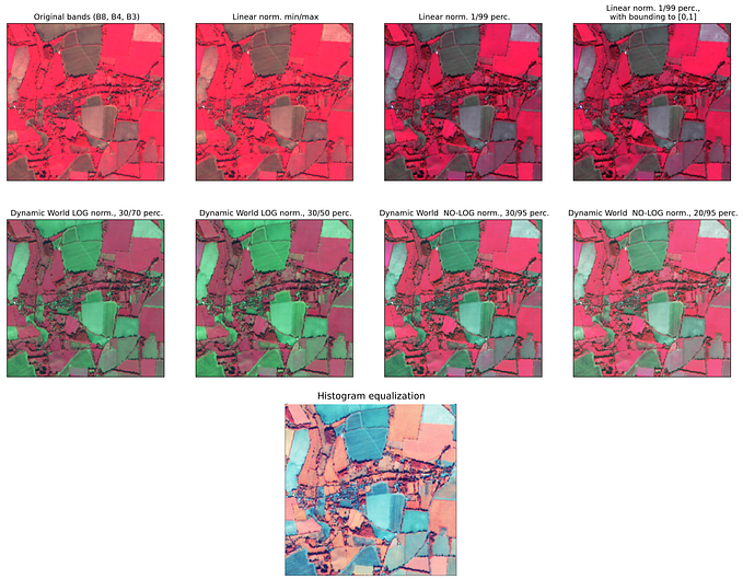
- We retrieve relevant data from Earth Observation satellite image repositories, including multispectral images (SENTINEL 2 satellites), NDVI time series, Soil organic carbon estimation. A Deep learning model for semantic segmentation divides the area into polygons with homogenous land cover
- For each polygon two co2 estimates are calculated : (a) Vegetation co2 absorption is based on the NDVI, and is calculated as the integral of the NDVI for the last year; (b) Soil organic carbon (SOC) stock is a vital component of soil with important effects on the functioning of terrestrial ecosystems.
All this data is then displayed for the end user through a simple & clear map based interface:


Uses & next steps
LandPro can help self-evaluation by farmers, comparing different managements of cropland and extracting trends and other significant variations. Currently LandPro is a simple interface to harness data from different sources in a meaningful way. In time LandPro can become a reference for validating self-assessment, sharing successes and improve adoption of positive practices among farmers, land managers and more.
Functionality improvements:
- Better estimates of co2 absorptions /emissions can be calculated combining land cover type with multispectral images. Several scientific papers have been published on the topic, and we expect methods and models to improve greatly in the near future
- More interactivity: modifying polygones boundaries, adding spatial elements, describing land management practices each subareas are functionality that can be easily integrated within the user interface
- Visualisation of co2 changes in time: What is the trend, have there been major changes in the recent past. SOC estimates could be updated real time based on sentinel images and latest sampling data.
- Comparison with neighbouring areas: LandPro can easily provide information not only on the area of interest entered by the user, but also for the neighbouring similar areas. This could provide the user of an estimates of its performance, but also suggest locations where better practices may be found
How did it go:
Here is the link to the daily vlog I did during the hackathon: